Fatimid Cairo - Exploring the Cairo of the Fatimids
Fatimid Cairo refers to the city of Cairo during the Fatimid dynasty, founded by Jawhar al-Sifaqi in 969 AD as the capital of the dynasty. It encompasses the Mu'ezz Street and the Citadel, and includes prominent historical landmarks such as Al-Azhar Mosque and Bab Zuwayla. It has been listed as a UNESCO World Heritage Site under the name "Historic Cairo".
The Rise of Cairo:
After the Fatimids entered Egypt under the leadership of Jawhar al-Sifardi on 17th of Sha'ban 358 AH / 6th July 969 AD, following their conquest of the Ikhshidid dynasty, Jawhar al-Sifardi conceived the idea of building a new capital for the Fatimid Caliph al-Mu'izz, who was still residing in North Africa. It is noteworthy that establishing a new capital became a common practice for emerging states. However, the construction of a new capital for the Fatimids in Egypt was of particular significance, unlike any previous state, as its purpose was to spread Shi'a Islam in Egypt and establish its foundations there, making Egypt a center for its dissemination throughout the rest of the Islamic world, according to the plan the Fatimids had devised upon their arrival in Egypt.
The Founding of Cairo:
On the evening of that day, Jawhar marked out the site for the palace where he planned to receive al-Mu'izz, following the orders of his lord. When the notables of al-Fustat arrived the following morning to congratulate him, they found that the foundations for the new building had already been dug. Jawhar then built an outer wall of mud bricks in the shape of a square, each side measuring 1200 yards. The area enclosed by this square was 340 feddans; of this, approximately 70 feddans were used for Jawhar's large palace, 35 feddans for the al-Kafuri garden, and another 35 feddans for open spaces. The remaining 200 feddans were distributed among the military units in about twenty barracks along both sides of the main street of Cairo. Because Jawhar had hastily dug the palace foundations during the night, they developed uneven cracks. When he saw them in the morning, he was displeased, but he said, "It was dug on a blessed night and at a propitious hour," and left it as it was.
On the day Jawhar laid out Cairo, each of the Shi'ite tribes that comprised his army took its designated area. The Zazawila tribe settled in the area that bears its name to this day, the Barqa tribe established the Barqa quarter, and the Rum tribe established two quarters, al-Baraniya and al-Jawaniya, near Bab al-Nasr. Jawhar's purpose in founding Cairo was to create a strong fortress to defend al-Fustat from the Qarmatians, allowing him to fight them from outside the city. He surrounded his troops' camp with the mud-brick wall, built a mosque and a palace within the walls, and dug a trench on the northern side to prevent the Qarmatian army from invading Cairo and Egypt beyond it. Regarding the palace built by Jawhar, Ibn Dughmaq explained the purpose for which Jawhar built it, stating that he built it for his lord so that he, his aides, and his army could be isolated from the general public.
The Location of Old Fatimid Cairo:
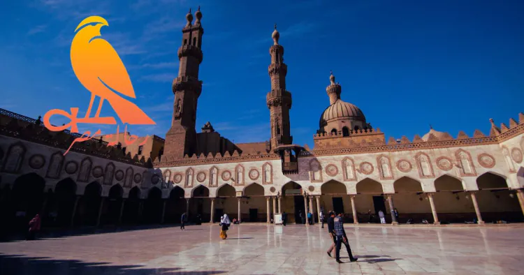
After the Fatimids conquered Egypt, the Fatimid army marched north for a distance of approximately four kilometers. This area consisted of orchards and suburban dwellings, and it was prone to flooding, with water pools remaining after the Nile's annual floodwaters receded. They finally reached the site where the city of Cairo was established. It was a sandy plain, interspersed with some elevated rocky areas, through which the Nile flowed on its way from Fustat to Ayn Shams on the eastern bank of the Nile. There were few signs of human settlement in this area. The city of Cairo was located north of Fustat and Al-Qata'i', and at its inception, it was relatively small, extending from Bab al-Futuh in the north to Bab Zuwayla in the south. The Al-Mu'izz Street, which now contains 32 Islamic monuments, runs through its center. It was bordered to the east by the Muqattam Hills, to the west by the Nile, and to the south by the city of Al-Qata'i'.
Names of Cairo:
It has been said that when Jawhar finished building the caliph's palace and erected a wall around it, he initially named the city Mansuriya, after the city of Mansuriya founded by al-Mansur Billah, the father of al-Mu'izz, outside of Kairouan. This name remained until al-Mu'izz arrived in Egypt, when he renamed it Cairo, four years after its founding. As Wright-Righter pointed out in her book, it is clear that we can assume that the general Jawhar had received instructions from the caliph to establish a city that would be to Fustat what Mansuriya was to Kairouan , or like Versailles to Paris or Windsor to London. It is worth noting that al-Bakri mentioned that two of the gates of Mansuriya were called Bab Zuwayla and Bab al-Futuh, and these same names were later given to two gates of the walls of Cairo.
On Tuesday, the 6th of Ramadan, 362 AH (June 10, 973 AD), when al-Mu'izz arrived in Cairo with his family, he ignored Fustat, which had been decorated in anticipation of his arrival. He then went to the Great Palace and ordered the construction of a tomb for his ancestors, whose bodies he had brought with him in coffins. At the end of Ramadan, he led the Eid prayer himself at al-Azhar Mosque and delivered the Eid sermon. The first prayer had been held at al-Azhar Mosque on Friday, the 6th of Ramadan, 361 AH (June 11, 972 AD).
It seems that when Jawhar initially founded the fortified city of Cairo, his intention was not to make it a capital or seat of the caliphate, but rather a residence for the caliph, his family, his army, his close advisors, and a fortified stronghold for defense and refuge. Cairo thus emerged as the capital city of the nascent Fatimid state and remained a royal and military center, housing the palaces of the caliphs, the residences of the princes, government offices, and the treasury and arsenal. Four years after its founding, it became the capital of the Fatimid Caliphate when al-Mu'izz and his family moved there from Morocco, settling in the Great Eastern Palace. The caliph made Egypt his permanent residence, arriving there on Tuesday, 6 Ramadan 362 AH, corresponding to June 10, 973 AD. No one in Egypt could enter Cairo without a special permit allowing them to pass through the city gates. Foreign envoys attending official ceremonies would dismount from their horses and be escorted to the palace between two rows of soldiers, following the Byzantine custom. The high walls and guarded gates of Cairo shielded the caliph from the view of his subjects.
But over the years, the nascent city expanded and grew considerably. Cairo began its history under the Fatimid caliphs and attained its great stature and splendor. Later, it merged with Fustat, and together they became the largest Islamic city in the Middle Ages.
Reasons for naming Cairo:
1: One reason given is that its construction began when the planet Jupiter (also known as "Al-Qahir" in Arabic) was visible in the sky.
2: Another reason is that Al-Mu'izz chose this name with the hope that his new capital would surpass all previous capitals and cities, a name signifying power and glory.
Reasons for choosing that location to build Cairo:
Historical sources indicate that Caliph Al-Mu'izz left the choice of the site to his general, Jawhar. However, when the Fatimid caliph arrived in Egypt, he criticized Jawhar for his choice of location, as Al-Mu'izz wanted to build his capital south of Fustat, in the area of Tell al-Rasad. In fact, the site chosen by Jawhar for Cairo conformed to the urban planning tradition of the Islamic capitals of Egypt, starting with Fustat, then Al-Askar to the north, followed by Al-Qata'i to the northeast, and finally Cairo further north, with gardens and ponds interspersed along the way. This location also allowed for the beneficial use of the prevailing north-south winds. This area was suitable for urban expansion, as it stretched between the mountain and the Nile, offering ample flat land for construction. The location of the al-Muqattam hills, especially to the east of Cairo with the Nile to the west, provided an important defensive advantage.
The Layout of Cairo:
In light of archaeological studies and historical sources, it is clear that the city of Cairo, in its initial urban development phase, had a distinctive layout. This city was built as a fortified royal citadel. Its street network consisted of a main thoroughfare running from north to south, starting at Bab al-Futuh in the north and ending at Bab Zuwayla in the southern wall.
From this main street, secondary streets branched off, running east to west, intersecting the main street, "Qasbat al-Qahirah," at right angles. These streets separated the areas designated for tribal residences, known as neighborhoods or "haras." Each neighborhood had one or two entrances onto these streets, and the houses within the neighborhood opened onto a network of narrower alleys.
This layout ensured that each neighborhood maintained its privacy; only its residents could enter. When the outer gate of a neighborhood was closed at night, entry was impossible, making it easy to defend against attack. The layout of Cairo adhered to the established principles of city planning, dating back to the 5th century BC, which the Greeks and Romans used in their ancient empires, and which were originally derived from ancient Egyptian cities.
The city was initially built as a royal fortress to defend against the threat of the Qarmatians, and later, after the arrival of al-Mu'izz from Mansuriya in Tunisia, it became the capital of the Fatimid Caliphate. The location of key structures and the division of land were determined based on this vision. In its initial phase, under Jawhar al-Sikilli, Cairo covered an area of 370 feddans (approximately 155 hectares). The eastern palace occupied 70 feddans, while public squares and gardens each occupied 30 feddans. The residential areas, streets, and roads covered an area of 210 acres. Thus, we can say that the nature of the city, as a royal city, led to its planning being oriented towards serving this purpose, whether regarding the palace, the squares, or the location of the mosque. This also applies to the Eid prayer mosque and the neighborhoods designated for the residence of the soldiers and the royal entourage. We can clearly see this in some features, such as the location of the Great Mosque south of the palace, near Bab Zuwayla, which connected Cairo with the previous Egyptian Islamic capitals.
This was to facilitate access for those who wished to pray Friday prayers at this mosque, without having to enter the palace area. Similarly, the large size of the palace, the construction of the Western Palace opposite it, and the creation of a parade ground between the two palaces, all reflect this royal design. This planning is linked to the royal architectural style that had already been established in the first Fatimid city of al-Mahdiyya, a trend that emphasized the Fatimids' presence in their new capital in Egypt.
Furthermore, the location of the Eid prayer mosque outside Bab al-Nasr, and the planned route leading to it from the palace through Bab al-Eid to a road leading to Bab al-Nasr, from which the caliph would return to the palace via Bab al-Futuh, was intended to ensure that the caliph did not return by the same route he took to go to prayer, thus emulating the Prophet (peace be upon him). This is an aspect of the royal conduct of al-Mu'izz. Historical sources indicate that al-Mu'izz was very keen to observe the Sunnah (Prophetic traditions) and adhere to them meticulously, not only as a Muslim, but also as a way of emphasizing his lineage to the Prophet Muhammad (peace be upon him).
What's Your Reaction?